May 06, 2021
The Power of Satellite Imagery In Agriculture & Farming


Agriculture is often viewed as an industry that is slow to change and antiquated in its practices While the agriculture industry is steeped in meaningful and important traditions and heritage however, it also has embraced leading technological advances and is employing them in innovative and powerful ways.
For example, the ubiquitous nature of satellite imagery and GPS technology in the modern age has dramatically improved the capacity and abilities of both agricultural researchers and farm/ranch managers. From a desk at the farm headquarters, a farmer can now monitor the evapotranspiration levels in the crops and deliver water precisely to match those levels. They also can monitor changes across the growing season for fields.
The power of satellite imagery comes from the prolific satellite imagery data that is now readily available, but where does this data come from, who maintains the satellites, and are all satellites the same?
Satellite Data Products
Let’s start with the one we all know, Google. Google has compiled what is likely the largest publicly accessible database of satellite imagery in the world (of course, governments all have their own databases as well) and has made these data available and usable through Google Earth, Google Maps, and Google Earth Engine. These programs allow users to view, create, and analyze image data to better research land trends, land uses, management history and so much more.
Next time you log into Google Earth or your favorite mapping software, take a look at the bottom of the map.

What you will find is the data sources of the satellite imagery. Google, for instance, may be a wonderful compiler of satellite data but they do not actually manage or own any satellites (they sold the ones they did operate in 2017). Google then purchases or acquires satellite data to use in its mapping products from the U.S. government and other private satellite operations companies that manage the satellites themselves. You can typically see the source of any satellite imagery at the bottom of any interactive map..
While there are various private companies entering into the satellite ownership and operations business, the U.S. Federal government has been operating the Landsat satellite program since 1972, and these cameras capture not only images but also spectral imaging data which can be used for vegetation monitoring and various other calculations. These data just recently became publicly available and are now being used in research and web tool development in various agricultural sectors around the globe.
What is Satellite Imagery Data?
Not all satellites (and their subsequent image data) are created equal. Various companies (and governments) that operate satellites have different purposes for the satellites and the data they create becomes available at different spatial resolutions, and time scales. Satellite data are compilations of millions of pixels that relate to a distance on earth. Sometimes, a pixel can represent one square meter of on the ground space it can be 30 m2, 1km2, or even larger. Every year, however, the technology gets better and spatial resolutions capabilities are nearing levels closer to square centimeter resolutions.
The temporal measure of satellite data is also relevant. Current Landsat satellites, for example, circle the earth every 16 days, so you can get an estimate of a specific change only every two weeks or so. Many other data products that are created with satellite images (such as land use data) are only created at the annual level.
Using Satellite Imagery for Remote Sensing
Capturing images and spectral light measurements from space can be quite useful as a standalone product, but these data become incredibly powerful when they are combined with on the ground monitoring points. This process, known as remote sensing, is the process where satellite imagery data are matched with on the ground samples (such as weather station data, soil samples, vegetation surveys, etc.) to create condition estimates at various spatial scales. As a result, we can estimate conditions in locations where no on-the-ground measurement was taken. As technology continues to improve, the power and abilities of remote sensing are growing quickly.
One application of remote sensing products is the incorporation of precision agriculture into farm management. This is the process by which a farmer uses remote sensing as well as on-farm data and complex algorithms that convert these data into production estimates to inform input decisions, such as variable-rate fertilizer application rates or optimal watering amounts. The use of these methods is helping agricultural producers across the U.S. be more strategic in their allocation of scarce or expensive resources and prioritize profit and sustainability simultaneously.
Another area of ongoing research in remote sensing science is how to match on the ground soil organic carbon estimates with satellite imagery to best estimate changes in carbon stocks across time while minimizing the cost of on the ground sampling. These efforts are being explored by the carbon market companies, like Indigo Ag and Regen Network, as well as researchers and agency personnel from the USDA and universities around the globe.
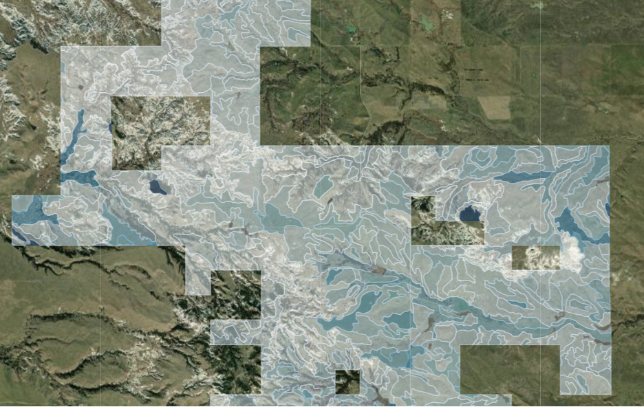
Caption: The USDA NRCS gSSURGO dataset is a remote sensing soil data product that now includes soil organic carbon estimates which can be applied to a farm or ranch to see most carbon rich locations as shown in the map above where darker blue locations have high carbon stock estimates.
Harnessing the Power of Space
Remote sensing and satellite imagery data are being used around the globe by the agricultural industry to make decisions, understand changes, and estimate future conditions. Just like forecasting commodity price data, researchers and industry professionals are using these spatial data to forecast changes to conditions under different management strategies, climate scenarios, and market pressures.
The technology around remote sensing is rapidly developing and there are new private industry actors and innovations all the time. For example, Planet Labs has recently launched derived data feeds at daily temporal resolution and 1-5 square meter spatial resolution for studying land cover change. As the spatial data available becomes less and less aggregated across time and space, and cloud computing and cloud storage capacities increase, remote sensing products are sure to see massive improvement in their capabilities and accuracy.
As Farmtogether looks to buy and lease out different farming operations around the country, satellite imagery and remote sensing products prove important in these decisions for understanding historical management and conditions. Now, with the power of time-series satellite imagery and remote sensing products, the knowledge of the farm managers can be combined with satellite data to tell a complete history of the farm and give confidence to investors in the capacity of the operation.
For individual farmers, as they grow in size, remote sensing technology is helping managers keep track of conditions and monitor growth, weather, and carbon with newfound ease and surprising accuracy. While these products aren’t perfect, they are improving every day and making day to day farm management simpler and can help managers demonstrate their conservation and management efforts in an easily understandable and visually appealing way.
Satellite imagery is changing the way business is done in the agricultural sector. Managers, researchers, and investors now all have access to data that can improve decision making and push the industry to a place of better soil health, more efficient production, and happier farmers.
Click here to see farmland's historical performance, visit our FAQ to learn more about investing with FarmTogether, or get started today by visiting ways to invest.
Disclaimer: FarmTogether is not a registered broker-dealer, investment advisor or investment manager. FarmTogether does not provide tax, legal or investment advice. This material has been prepared for informational and educational purposes only. You should consult your own tax, legal and investment advisors before engaging in any transaction.
Was this article helpful?